So I was just having a look on google maps and found a drain exit on the edge of a park which doesn't seem to have another end to it anywhere close. I followed the telltale signs of a drainage route under the suburbs with long strips of grass, walking tracks and strips where nothing has been built on but it ends abruptly at a road in an industrial area, i can see no tunnel endings so I'm guessing it goes under the road, but from there I'm not sure, I noticed another creek nearby which has a drain outlet which is pointing to where my estimated drain route ends but the tunnel running between these 2 points would have to go underneath a national airport (Essendon Airport in Melbourne). If it does, well that could be interesting who knows how many backup drains there may be to prevent the airport from ever flooding.
___________________________________________________________________________________
The guide
Note: The underlined sections of text are links to the location of key points on google maps which help with finding your drain.
Fire up Google Earth or the web based Google Maps now and fill the view with the Melbourne CBD and surrounding area like so.

From a sattelite view of the entire of Melbourne I can see the Maribyrnong river running from the north west of the city into to the west of the Melbourne CBD and eventually into Port Phillip bay. Naturally, smaller creeks will run into this river.
From the bay, follow the Maribyrnong back up stream past Flemington race course on the right all the way up to the big bend in Essendon West near Buckley Street. Here you will find a creek running into the Maribyrong River, follow it north watching to see if it ends abruptly anywhere. Eventually the creek runs through a large tunnel under the Calder Freeway in Keilor East. This is where we can see that there is some water running from a seperate tunnel coming out from under a park.
Here's a picture of the tunnel exit from satellite imagery:

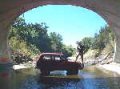
And we can see a photo of it if we place our StreetView marker on Fullarton Road:

This tunnel looks to be running north east into the park towards a walking track which runs through the suburbs up into an industrial area, you'll notice that though they could have extended the fencelines of the properties further back closer to the walking track when they plotted the land, instead they left a long strip of grass. Rather, the strip of grass was left so that they could build a drainage tunnel there. (Sometimes large powerline towers are built on these strips too) Instead of wasting the land they built a nice walking track along the grass strip which connects to other parks along the way. By Australian law, they are not allowed to build any structures such as houses on top of and within a certain distance of these drains in case they need to be dug up for repairs, if you look closely in satellite view you can even see the big metal drain grates in the ground as dark circles/rectangles. These grass strips are a key to finding drain systems, you will notice they always come out into a park and usually point straight towards a drain exit which runs into a creek.
Here is the route along one of these grass strips, marked in red. We are following it from the tunnel exit we found near Calder Freeway in the bottom left corner and heading north east along the red line.

When we reach The end of the grass strip. is when we have to start guessing where the tunnel goes next, or to decide that it may end here and this grass strip just runs along the bottom of a valley to which all of the nearby suburban road's stormwater drains run into. Let's suppose that it doesn't end here and it must keep going under the roads (this could be plausible as they can place man-holes on the road/nature strip for access in case repairs are needed. Having a quick look further to the North East we find another creek, I looked along the banks of the creek and found Another drain exit running into it

Funnily enough this drain is heading back towards the end of the grass strip. This is where I just assumed that the two points must join up, I found a couple of drain grates behind the fences of houses just to the west of the last drain outlet we found which helped me estimate a route. The problem is there is a large airport between these 2 points, the drains may go straight under the runway and across the airfield or maybe they curve around the outside of the airport boundaries and join up under the roads north of the end of the grass strip.
This is about all the information I could gather from looking at this area, there could be a large junction room anywhere along this route which tees off into other tunnels leading elsewhere which is an exciting prospect.
The only way to find out more now would be to go there and explore it yourself!
I hope this guide gave you a vague idea of how to find drainage routes under your cities. If you can see a huge entry that doesn't just go under a road anywhere on google maps It's worth checking out, this helps find the possible big stuff I suppose.
Be Safe!
-Trezza